|
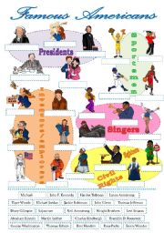
Famous Americans-label the pictures
The students label the pictures of famous Americans (a cut-and-paste activity) and prepare a report about the person they admire.
Level: intermediate
Age: 12-17
Type: worksheet
Downloads: 82
|
|
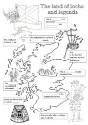
Scotland - fill in the missing info
Students fill in the gaps with the missing information about Scotland.
Level: elementary
Age: 9-12
Type: worksheet
Downloads: 319
|
|
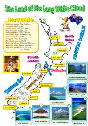
New Zealand map (reuploaded)
I decided to improve my map and added some pictures of the natural wonders (ofcourse I had to delete my previous document). Hope your students will like it. Laminate this map and display it in your classroom. BTW, I changed the map of Canada as well (if you�re interested in the better version, visit the 3rd page of my account).
Level: intermediate
Age: 12-17
Type: worksheet
Downloads: 282
|
|
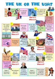
The UK or the USA-board game
The students read the statements and say if they are about the UK or the USA.
Level: elementary
Age: 12-17
Type: worksheet
Downloads: 298
|
|
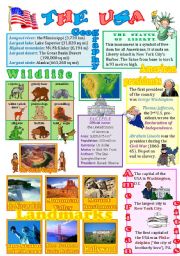
The USA wall poster
The 2nd ws of the series (the 1st one was about Australia)with the basic info about the U.S. landmarks, cities, presidents, animals and lots more. As usual, fully editable. I express my gratitude to Phillip Martin for these FANTASTIC pictures. Tomorrow I�ll upload a ws about Canada. Hugs from freezing Russia.
Level: intermediate
Age: 12-17
Type: worksheet
Downloads: 445
|
|
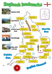
England: landmarks
A fully editable map of England with landmarks.
Level: intermediate
Age: 12-17
Type: worksheet
Downloads: 298
|
|
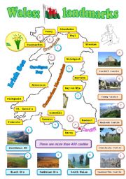
Wales: landmarks
A fully editable map of Wales - the land of princes and castles. Hope it�s useful. I use my maps as posters. Hugs from Russia.
Level: intermediate
Age: 12-17
Type: worksheet
Downloads: 259
|
|
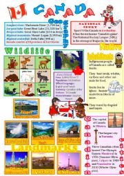
Canada wall poster
The 3rd part of the series - this time about Canada (its landmarks, native inhabitants, wildlife, cities...).
Level: intermediate
Age: 12-14
Type: worksheet
Downloads: 444
|
|
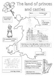
Wales - fill in with the missing info
Students fill in the gaps with the missing info about Wales.
Level: elementary
Age: 9-12
Type: worksheet
Downloads: 282
|
|
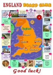
England board game
The 2nd ws of the series (the first one was about Scotland). ANSWERS: Stonehenge-London-Albion-a red rose-a double-decker bus-the Severn-the white cliffs of Dover-5 cities: London, Manchester, Liverpool, Brighton, Bornmouth-Punch and Judy-the Pennines-football and cricket-5 clubs: Chelsea, Arsenal, Manchester United, Manchester City, Liverpool-lake...
Level: elementary
Age: 9-12
Type: worksheet
Downloads: 153
|