|
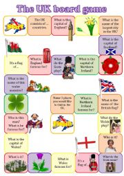
The UK boardgame
A fully editable board game to revise the main info about the UK: countries, their capitals, symbols, landmarks and the structure �TO BE FAMOUS FOR�. In a stronger class the students may not just answer the questions, but give as many details as possible.
Level: intermediate
Age: 12-17
Type: worksheet
Downloads: 178
|
|
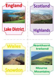
THE UK FLASHCARDS 6 - NATURAL WONDERS (1)
The sixth set of flashcards about the UK is dedicated to nature.
Level: intermediate
Age: 12-17
Type: flash-card
Downloads: 94
|
|
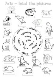
Pets-label the pictures
The students label the pictures of pets using the hints.
Level: elementary
Age: 7-10
Type: worksheet
Downloads: 122
|
|
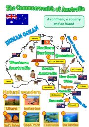
A map of Australia
A map of Australia with the names of provinces, territories, their capitals, flags, wildlife and some landmarks can be used as a visual aid while speaking about the Green Continent.
Level: elementary
Age: 10-17
Type: worksheet
Downloads: 175
|
|
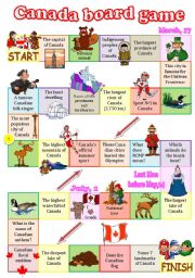
Canada board game
A fully editable board game dedicated to Canada. As usual, several categories: geography, cities, wildlife, indigenous peoples, sports, festivals, symbols... The questions aren�t that difficult but I�ll provide you with the answers for a couple of them: a famous Canadian folk singer - Stompin�s Tom Connors, RCMP stands for Royal Canadian Mountain P...
Level: intermediate
Age: 13-17
Type: worksheet
Downloads: 248
|
|
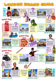
London board game
This board game helps to revise the names of London sights and the main facts about the British capital.
Level: elementary
Age: 10-17
Type: worksheet
Downloads: 353
|
|
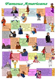
Famous Americans board game
With the help of this board game the students revise the names of outstanding Americans (there are presidents, famous women, singers, sportsmen, pioneers, explorers, inventors, Native Americans).
Level: intermediate
Age: 12-17
Type: worksheet
Downloads: 204
|
|
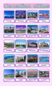
Canadian cities pictionary
20 most densely populated Canadian cities.
Level: intermediate
Age: 12-17
Type: worksheet
Downloads: 46
|
|
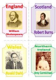
THE UK FLASHCARDS 5 - FAMOUS POETS (WRITERS), 1 page, fully editable
The fifth part of my set is dedicated to people who glorified their countries.
Level: intermediate
Age: 12-17
Type: flash-card
Downloads: 106
|
|
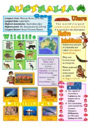
Australia wall poster (fully editable)
A wall poster with the basic info about the Green continent - its wildlife, native inhabitants, cities, landmarks. Clipart by Phillip Martin.
Level: intermediate
Age: 12-17
Type: worksheet
Downloads: 469
|