|
Printables |
PowerPoints |
Online exercises |
|
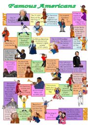
Famous Americans board game
With the help of this board game the students revise the names of outstanding Americans (there are presidents, famous women, singers, sportsmen, pioneers, explorers, inventors, Native Americans).
Level: intermediate
Age: 12-17
Type: worksheet
Downloads: 204
|
|
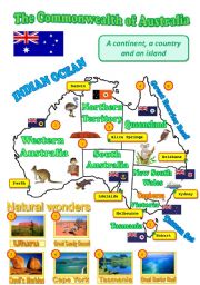
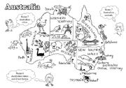
A map of Australia
A map of Australia with the names of provinces, territories, their capitals, flags, wildlife and some landmarks can be used as a visual aid while speaking about the Green Continent.
Level: elementary
Age: 10-17
Type: worksheet
Downloads: 175
|
|
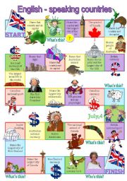
English-speaking countries board game
This board game helps to revise the general info about the English-speaking countries in an enjoyable way. Each colour corresponds to a particular country (yellow squares - questions about Australia, green squares - the USA, purple squares - the UK, pink squares - Canada, blue squares - New Zealand).
ANSWERS:
Australia: Canberra - aborigines - pl...
Level: intermediate
Age: 13-17
Type: worksheet
Downloads: 700
|
|
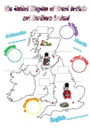
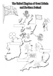
The UK: cut-and-paste activity for young learners (2 pages, fully editable)
Students cut out the names of the countries, their capitals, floral emblems, flags and paste them to the correct places on the map. They may colour the countries and use this map as a prompt while speaking about the UK. Clipart by Phillip Martin.
Level: elementary
Age: 9-17
Type: worksheet
Downloads: 226
|
|
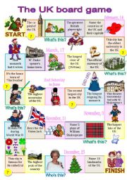
The UK board game for intermediate students (fully editable)
Another board game on the topic �The UK�. This time the questions are more challenging. There are 7 categories: general info, geography, cities, sights/icons, festivals, W. Shakespeare, monarchs/prime ministers. If the student gives an incorrect answer, he/she misses the turn. Clipart by Phillip Martin.
Level: intermediate
Age: 14-17
Type: worksheet
Downloads: 501
|
|
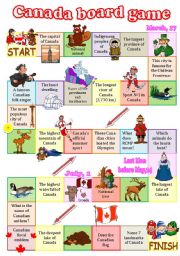
Canada board game
A fully editable board game dedicated to Canada. As usual, several categories: geography, cities, wildlife, indigenous peoples, sports, festivals, symbols... The questions aren�t that difficult but I�ll provide you with the answers for a couple of them: a famous Canadian folk singer - Stompin�s Tom Connors, RCMP stands for Royal Canadian Mountain P...
Level: intermediate
Age: 13-17
Type: worksheet
Downloads: 248
|
|
The UK: black-and-white map for young learners
A black-and-white map of the UK. Students label the countries, draw the borders, colour the landmarks.
Level: elementary
Age: 10-12
Type: worksheet
Downloads: 311
|
|
Australia - a black-and-white map for young learners (editable)
I don�t remember where exactly I found this map but... anyway, it looks fantastic and I couldn�t but share it with you. As for the task, kids are to colour the map according to teacher�s instructions, colour the animals and say what they know about Australia using the hints (they name the animals, the cities, states and territories). Of course, it�...
Level: elementary
Age: 9-12
Type: worksheet
Downloads: 223
|
|
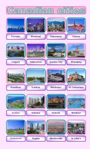
Canadian cities pictionary
20 most densely populated Canadian cities.
Level: intermediate
Age: 12-17
Type: worksheet
Downloads: 46
|
|
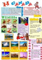
Canada wall poster
The 3rd part of the series - this time about Canada (its landmarks, native inhabitants, wildlife, cities...).
Level: intermediate
Age: 12-14
Type: worksheet
Downloads: 443
|
|
|
|
|