|
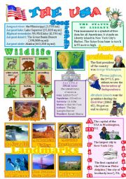
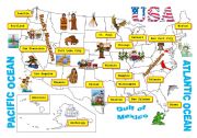
The USA wall poster
The 2nd ws of the series (the 1st one was about Australia)with the basic info about the U.S. landmarks, cities, presidents, animals and lots more. As usual, fully editable. I express my gratitude to Phillip Martin for these FANTASTIC pictures. Tomorrow I�ll upload a ws about Canada. Hugs from freezing Russia.
Level: intermediate
Age: 12-17
Type: worksheet
Downloads: 444
|
|
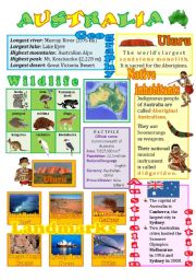
Australia wall poster (fully editable)
A wall poster with the basic info about the Green continent - its wildlife, native inhabitants, cities, landmarks. Clipart by Phillip Martin.
Level: intermediate
Age: 12-17
Type: worksheet
Downloads: 469
|
|
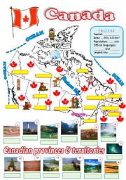
Map of Canada - 2 (fully editable)
The students are to fill in the map with the names of Canadian provinces and territories, their capitals, the names of the oceans and some info in the factfile.
Level: intermediate
Age: 12-17
Type: worksheet
Downloads: 301
|
|
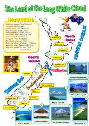
New Zealand map (reuploaded)
I decided to improve my map and added some pictures of the natural wonders (ofcourse I had to delete my previous document). Hope your students will like it. Laminate this map and display it in your classroom. BTW, I changed the map of Canada as well (if you�re interested in the better version, visit the 3rd page of my account).
Level: intermediate
Age: 12-17
Type: worksheet
Downloads: 282
|
|
USA-map
A map of the USA. Clipart by Phillip Martin.
Level: intermediate
Age: 13-17
Type: worksheet
Downloads: 210
|
|
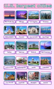
U.S. largest cities pictionary
20 most densely populated U.S. cities. Fully editable. Have a good day!
Level: intermediate
Age: 13-17
Type: worksheet
Downloads: 75
|
|
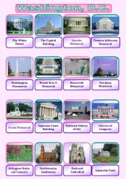
Washington, D.C. pictionary
A wall poster for students to memorize the places of interest of the U.S. capital.
Level: intermediate
Age: 14-17
Type: worksheet
Downloads: 122
|
|
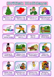
British Holidays Pictionary
Major British holidays. Phillip Martin rules the world.
Level: intermediate
Age: 13-17
Type: worksheet
Downloads: 226
|
|
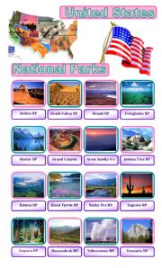
U.S. National Parks
A wall poster with top 16 U.S National Parks
Level: intermediate
Age: 13-17
Type: worksheet
Downloads: 153
|
|
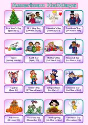
American Holidays pictionary
Major American holidays. Thanks a lot to Elizabeth for her fantastic template and to Phillip Martin for his lovely clipart.
Level: intermediate
Age: 13-17
Type: worksheet
Downloads: 238
|